Hudson Valley Snow Closings, Delays for October 2016 Storm
Update -- Thursday, Oct. 27 at 9:42AM:
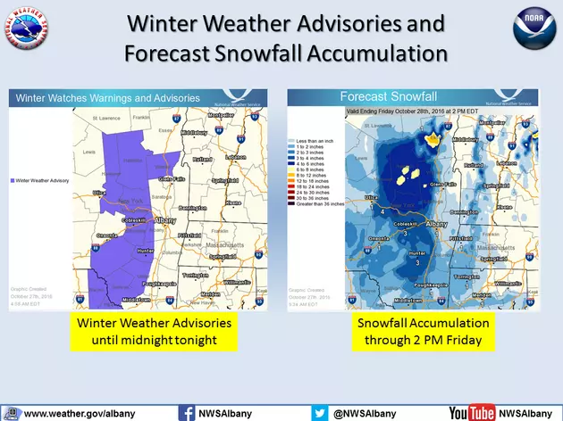
Most of the Hudson Valley missed a slushy, snowy commute Thursday morning. The heavier winter precipitation began after 8AM and should last until 11AM, according to National Weather Service (NWS) Albany.
Western portions of Ulster County could receive up to 3 inches, but the accumulation for Ulster and Dutchess counties will be in the 1- to 3-inch range.
Our storm center hasn't received reports of storm closings or delays as of this time.
Original story:
We've had a few instances of October snow in the Hudson Valley in recent years. Nevertheless, it still feels wrong having to dust snow off a pumpkin.
The Hudson Valley will see its first heavy dose of winter weather Thursday morning. Snow and sleet is expected to begin after midnight in Orange County, according to the National Weather Service (NWS). The light wintry precipitation will mix with rain in that part of the Hudson Valley before becoming all rain by noon. Accumulation could reach up to 1 1/2 inches in western parts of orange.
Dutchess and Ulster counties will see light snow Thursday morning before turning into rain in the afternoon. Western parts of Ulster County could see significant accumulation. The NWS Albany's forecast as of Wednesday afternoon predicted up to 6 inches in parts of the county.
We'll have storm updates posted to this page Thursday. You can use our storm center tool below to get the latest closings and delays for the Hudson Valley.
| 1) Select the category you would like to search by choosing the appropriate button next to "Name of Organization" or "City" 2) Type in part or all of the name, e.g. "pough" or "poughkeepsie" 3) Submit your request by clicking the "Submit Your Search" button. | ||
| Category: | Name of Organization | City | |
| Name: | |||
| Submit: | |||
(make sure the search box is clear above if you want to see all listings before clicking below)
More From Hudson Valley Post
